
The increasing demand for reliable navigation tools in remote areas, particularly among outdoor enthusiasts and specialized professionals like wilderness photographers, has brought a notable application into focus: the Garmin Explore app. This free-to-download mobile application offers robust offline navigation capabilities, addressing a critical need for users venturing beyond cellular network coverage. Its emergence as a standalone, free utility marks a significant development in accessible backcountry navigation, providing a viable alternative to dedicated hardware or subscription-based services.
The Evolving Landscape of Wilderness Navigation
For decades, navigating the wilderness primarily relied on traditional methods: paper maps, compasses, and meticulous planning. With the advent of Global Positioning System (GPS) technology, dedicated handheld devices from manufacturers like Garmin revolutionized outdoor exploration, offering precise location data independent of cellular networks. These devices, while highly effective, often came with a learning curve due to complex interfaces and represented an additional piece of equipment to manage.
The proliferation of smartphones introduced GPS capabilities to a mass market, integrating navigation into an everyday device. Applications such as Google Maps quickly became standard for urban and on-road navigation. Many of these apps also offered offline map downloads, seemingly bridging the gap for limited off-grid use. However, practical experience in truly remote wilderness areas, characterized by unpaved fire roads, faint hiking trails, or entirely unmarked terrain, frequently exposed the limitations of these general-purpose smartphone solutions. Users often reported instances of the device’s location icon "drifting" or failing to accurately pinpoint their position when removed from established road networks or strong signal areas, rendering them unreliable for critical navigation tasks.
This performance gap created a niche for specialized navigation solutions. While high-end Garmin GPS units and subscription-based apps like Gaia GPS or AllTrails offered superior mapping and features tailored for backcountry use, they often came with a significant financial investment or required ongoing subscriptions. The challenge remained for a free, reliable, and user-friendly solution that could democratize access to effective offline navigation.
Garmin Explore: Bridging the Gap
Garmin, a long-standing leader in GPS technology, traditionally designed its software, including the Garmin Explore platform, to pair with its proprietary hardware devices like the GPSMAP or InReach series. However, a pivotal development was the realization that the Garmin Explore app could function effectively as a standalone application on both iPhone and Android platforms, independent of a paired Garmin device. This independent functionality is particularly noteworthy as it leverages Garmin’s established mapping infrastructure and GPS expertise without requiring a hardware purchase.
The app’s ability to navigate flawlessly without cell signal, contingent on pre-downloaded maps, is its most compelling feature. Unlike some general-purpose mapping applications that may struggle with precision or detail in remote, off-grid environments even with downloaded maps, the Garmin Explore app consistently demonstrates a high degree of accuracy. This robustness is attributed to Garmin’s optimized map data handling and GPS integration, designed specifically for challenging outdoor conditions.
Key Advantages for Diverse Users
The Garmin Explore app’s free version offers a suite of functionalities that are particularly beneficial for various user groups:
- Exceptional Offline Navigation: The primary strength lies in its reliable performance when completely disconnected from cellular or internet service. Users can download various map types, including TopoActive maps, satellite imagery, and USGS quadrangle maps, for offline use. This ensures continuity of navigation in deep wilderness, dense forests, or high mountain ranges where signals are nonexistent.
- Intuitive Route Planning and Waypoint Management: The app boasts an intuitive user interface, allowing users to easily plan routes, mark critical waypoints (points of interest), and create tracks (recorded paths) directly on their smartphones. This ease of use contrasts sharply with the often-complex menu systems found on older dedicated GPS units, reducing the learning curve and frustration for new users. The ability to manage these navigational elements directly from a smartphone streamlines preparation for excursions.
- Seamless Website and App Synchronization: A significant advantage is the integration with the Garmin Explore website (explore.garmin.com). Users can create an account and plan detailed expeditions, marking waypoints, drawing tracks, and defining routes or courses on a larger screen. All data created on the website automatically syncs with the mobile app and vice-versa. This cross-platform compatibility enhances planning capabilities and ensures all navigational data is current and accessible across devices.
- Cost-Effectiveness and Accessibility: Perhaps the most attractive feature is its free availability. The app provides substantial mapping and navigation tools without any initial cost, advertisements, or persistent prompts to upgrade. This democratizes access to advanced outdoor navigation, making it accessible to a broader audience who might otherwise be deterred by the cost of dedicated devices or premium app subscriptions. The free version’s inclusion of TopoActive, satellite, and USGS quadrangle maps for offline use offers significant value.
Considerations and Limitations
While offering substantial benefits, the free version of the Garmin Explore app does present certain limitations that users should be aware of:
- Topographical Map Detail: The free TopoActive maps, while functional, may not offer the granular detail found in highly specialized topographical paper maps or premium subscription-based apps like Gaia GPS or AllTrails. For instance, micro-terrain features, subtle contour lines, or very specific geological details crucial for advanced mountaineering or detailed land navigation might be less pronounced. Users requiring the highest level of topographical detail might consider the Outdoor Maps+ plan for additional map layers or supplement with traditional paper maps.
- Terminology Specificity: Garmin employs distinct terminology for its navigational elements—Waypoints, Tracks, Routes, and Courses—which can initially be confusing due to their similar-sounding nature.
- Waypoint: A specific geographical point of interest marked by coordinates.
- Track: A historical record of a path taken, often displaying a breadcrumb trail.
- Route: A planned path connecting multiple waypoints, typically navigable point-to-point.
- Course: An active guide that directs the user along a pre-defined path, often with turn-by-turn or directional cues.
Understanding these distinctions is essential for effective use of the app’s planning features.
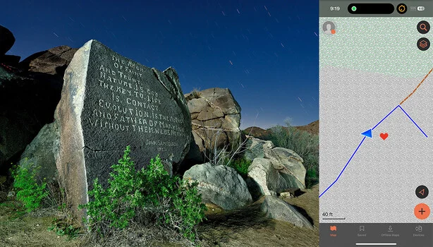
- Navigation Limitations Without Paired Device: When using the app independently, without a paired Garmin device, direct "navigate to waypoint" functionality as seen in dedicated units is not explicitly present. Users typically overcome this by creating a "course" in the area of their destination. Activating this course displays the user’s current position (represented by a blue arrow) relative to the planned path or waypoint, allowing for intuitive self-guidance. This workaround, while effective, represents a slight difference in workflow compared to hardware-integrated navigation.
- Smartphone Battery Dependency: Like all GPS applications running on smartphones, the Garmin Explore app can significantly drain battery life during extended periods of navigation or track recording. Smartphones, being multi-functional devices, inherently have shorter battery endurance for continuous GPS use compared to dedicated handheld units. This necessitates carrying external power banks or portable chargers, especially on longer excursions.
- Quirks and User Experience Refinements: While largely intuitive, the app has exhibited minor quirks in past iterations. For example, older versions might have temporarily disabled save functions when using voice input for waypoint naming. However, recent updates have addressed many of these minor issues, reflecting Garmin’s ongoing commitment to refining the user experience.
- The Indispensability of Paper Maps: Regardless of the sophistication of digital navigation tools, seasoned outdoor professionals consistently advise carrying a physical paper topographical map and a compass, especially in truly remote or high-stakes environments. Digital devices are susceptible to battery failure, physical damage, or technical malfunctions. A paper map serves as an invaluable, fail-safe backup.
Implications and Broader Impact
The availability of the free Garmin Explore app carries several significant implications for the outdoor community and the broader navigation technology market:
- Enhanced Safety and Accessibility: By providing reliable offline navigation tools without a cost barrier, Garmin Explore can contribute to greater safety for casual hikers and explorers. It lowers the barrier to entry for venturing into less-trafficked areas, potentially reducing instances of disorientation or getting lost, provided users understand its functionalities and limitations.
- Market Dynamics: The app strategically positions Garmin within the competitive landscape of outdoor navigation. It serves as an accessible entry point into the Garmin ecosystem, potentially converting free app users into customers for more advanced Garmin devices or paid Outdoor Maps+ subscriptions in the future. It also places competitive pressure on other free and paid navigation apps to continually enhance their offerings.
- Empowerment for Specialized Users: For niche communities such as night photographers, geocachers, or backcountry scientists who frequently operate in signal-deprived environments and often navigate to obscure, unmarked locations, the app offers a highly practical and efficient tool. Its accuracy in leading users to precise, pre-marked waypoints, even without established trails, is a critical enabler for their activities.
- Educational Tool: The app can also serve as an educational tool for individuals new to GPS navigation, allowing them to familiarize themselves with concepts like waypoints, tracks, and routes in a user-friendly digital environment before potentially investing in more complex devices or courses.
In conclusion, the Garmin Explore app, in its free iteration, stands out as a surprisingly robust and genuinely useful tool. It provides accurate, no-frills offline navigation, straightforward waypoint creation and management, and a clean, modern interface. While it may not fully replace a dedicated Garmin device paired with the app, or highly specialized subscription-based backcountry applications, it offers sufficient functionality for a vast majority of navigation scenarios encountered by outdoor enthusiasts, including photographers, hikers, and explorers. Its cost-free nature combined with Garmin’s proven GPS expertise makes it a compelling option for anyone seeking dependable navigation beyond the reach of cell service.
